Contents
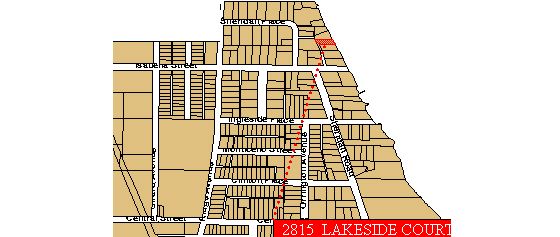
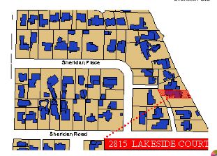
Location
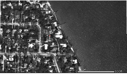
Maps of Evanston including aerial photos and zoning are available from the city of Evanston. The rough location and aerial photos are shown below and in more detail.
Photos taken in 1996 can be of the entire city or down to a few feet:

Pictures of the view from the house to the lake with a few pictures inside the former house. Thumbnails and some large pictures of lake views from the former house, the boathouse, and then a few from inside the house. (courtesy of D.R. Revelle)
Because it is on the lake, we need to consult with the Army Corps of Engineers who provide information about current, historic, and predicted lake levels. Weekly updates are available in terms of weather and lake levels. The current level is 10 inches below average and is about 8 inches above last year. It is 3 feet below the historic high for June and about 2 feet above the historic low. More importantly, however, it is 4 feet below the historic high water mark. There is a normal seasonal variation of about 1 foot with a high in July and a low in February. Currently, the boat house is about 6 feet above the water line which is about 18-24 inches deep. At historic high water, this means that the water would be about 5 feet deep at the boat house (two feet below the boat house deck). Because waves break in 1.5 times their depth, this implies that at highest water, 3.5 foot waves can and probably will cause significant damage inside the boat house. Even more importantly, I do not believe the water level projections include wind driven storm surge. (The former owner, Terry Nugent, showed us photographs of the damage caused at high water.) Projections for this spring and summer is that the water level should return to more normal levels.
Not only does the water level change seasonally, but so does the amount of sand. We saw an increase in sand level of about 1 foot during the winter and a subsequent washout this spring. This is presumably due to wave patterns and along shore drift. Similar effects are seen on the coast of California where the sand levels varies by up to 6 to 8 feet. It will take at least one year to detect the pattern at Lakeside, which is partly confounded with changes in lake level. We have one picture from several years ago of the sand level.
The lake level will have an effect on our seawall. Low lake levels lead to an outward pushing force pushing the steel retaining wall. Higher lake levels will counteract this force, but will be threatened by more wave action. As of now, we do not think that we need to add rip-rap for protection, but this needs continued study. Several houses about 200 meters north of our house have added large junks of rip-rap. Recently another house added an additional groin perpendicular to their sea wall.
Another issue of being on the lake is drainage. What are the regulations in terms of rain water runoff and of soil drainage? We can try to minimize runoff through the use of porous paving tiles. Samples from Scotland and Germany show some of the possibilities. By using these tiles we will reduce surface runoff at the cost of increasing the subsoil water table. (See the Nemo project, Nonpoint Education for Municipal Officials, web page for a discussion of how to prevent runoff and further considerations of municipal planning for water use). Grass pavers can be made of plastic (e.g., Grassy Pavers(TM)) or concrete. The NEMO page has a comparison of different products
Given the location, it is useful to know Sun and Moon rise times for a single day or all year. These data are kindly provided by the U.S. Naval Observatory in an interactive web page or in a spreadsheet form. These data are also available in an amazing program for the mac and PC: Time Palette. (The solar data are useful for planning for photovoltaic power and also window directions. The lunar data are interesting for watching the beauty of a moon rise.)
A more detailed analysis of the solar azimuths and altitudes during the year shows that the azimuth varies by about 66 degrees over the year, from 57 degrees at the summer solstice to 122 degrees at the winter solstice. (That is, East +/- 33 degrees). This table is useful when considering how to angle various rooms, the shading effects of overhangs in summer and winter, and the shading effect of our trees on solar panels. Additional information about solar elevations and azimuth during the day as a function of month has also been organized from the data provided by the USNO.